

Part of New Mexico’s Carson National Forest, the Valle Vidal is a pristine wilderness area in the Sangre de Cristo mountains that provides primitive camping at its finest. No hiking trails. No established campsites. No spider-infested latrines. Just you and the wild.
I undertook a solo day-trek in the Valle Vidal in the summer of 2001. This was the time when a GPS was but a boxy tablet that needed to be plugged into your computer in order to upload the mapping software.
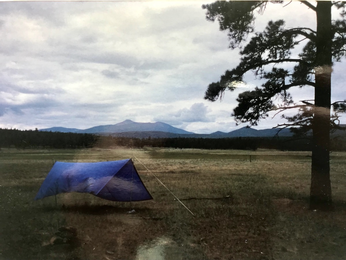
I awoke at sunrise, having pitched my tent near a cattle pasture in the former ranch. The bus stop was 15 miles away. The bus back to base camp arrived at 2pm. I had but a map and compass to navigate my way. In the words of Cosmo Kramer, “Giddy up.”
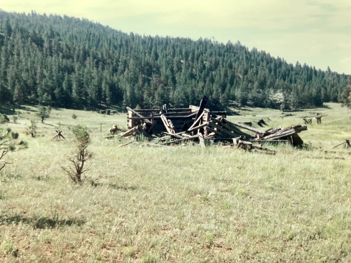
Step one easy. Head due south until I reach the creek. Step two was to follow the creek east until I find the ghost town. The foundational timbers of this abandoned mining village were still stacked atop each other, support beams leaning against piles of dilapidated wood. There was a small cemetery with tombstones dated from the days of Billy the Kid and Black Jack Ketchum.

Leaving the ghost town was the real test. I had to enter the woods and bushwhack my way southwest through the forest until I found an old windmill. After orienting the map and compass and finding my bearings, I meandered through the conifers. The beauty of the Valle Vidal, and why you can stomp about the woods without any trails, is there is virtually no underbrush. Just a soft bed of pine needles on the ground. It’s like a forest out of a fairy tale.
To wrap things up, I breathed a sigh of relief when I found the windmill. This was a big accomplishment for me considering I have the direction-sense of a stoned chipmunk. If I hadn’t found that windmill, I would have ended up another permanent resident of the ghost town (Clearly Clueless Nick).
From there I headed due south again until I hit the road, veering slightly to the west to overcorrect my direction. (Once I hit the road, I knew I had to turn east to find the bus stop.) I made it with about two hours to spare so I took a little nap in the cozy New Mexico sun.
This past Tuesday I hiked Singapore’s Railroad Corridor trail. It is nothing like the Valle Vidal. But what can you do? It’s Singapore.

The Rail Corridor
Here’s just my half-baked opinion about Singapore. Ever since the day Stamford Raffles declared this island a free port in the name of the East India Company, the Lion City has had one priority – commerce. There is nothing wrong with this. Singapore’s entry in the annals of history is one of glowing success.
But throughout the development of Singapore’s brief history, the construction of infrastructure has been devoted mostly to the needs of commerce. Massive harbors. Rail lines to move product across land. Sterling roads and highways that help commuters get to work as quickly and as efficiently as possible.
Now that Singapore has achieved financial and commercial stability, and is inhabited by a predominant wealthy class whose material needs have mostly been met, the people who make decisions around here realized Singapore is lacking in the soft amenities required by today’s jet set society. The new brand of expats want scenic beaches with hair-whipping watercraft, outdoor adventure that brings them face-to-face with their mortality, and green therapy.
To accommodate the paunchy expats who feel that getting back in touch with nature will heal their pandemic-induced emotional wounds, Singapore has made efforts to satisfy these misguided suburban adventurers.

They built some lovely new manmade beaches in Sentosa and along East Coast Park. But on the ocean horizon, instead of billowing clouds, rolling waves, or picture-perfect sunsets, there is an infinite line of transport ships waiting to unload. Singapore has bike trails, but the cyclists better stay off the road or contend with the contentious drivers. And they now have hiking trails.
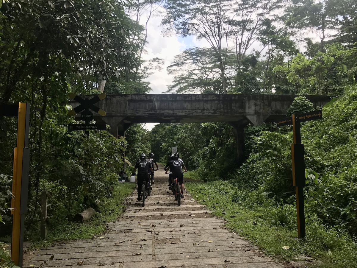
The major one being the Rail Corridor.

One academic referred to Singapore as a malarial swampy jungle paved in concrete and steel. Another said that if you walk through Singapore, you will see the jungle fighting back against the urban sprawl. Tree roots push up through the sidewalks. Monitor lizards greet unsuspecting occupants at their front door. Despite the island being constantly firebombed in mosquito repellant the little mozzies still infect joggers with that dang dengue fever.
As I walked along the Rail Corridor this week, I witnessed the forced marriage between modern Singapore and the native jungle.

Singapore’s first railway, the Singapore-Kranji Railway, was established in 1903 to haul goods from Keppel Harbor on Singapore’s southern tip up to Woodlands on the northern border and finally into Malaysia. The railroad was decommissioned in 2011 after more than 100 years in operation and the Singapore administration had the wherewithal to develop the existing route into a nice walking and bike trail.
The National Parks Board and the Urban Development Authority worked hard to make this a reality, removing non-native plants, replanting Singapore’s native rainforest flora, and reinviting the native fauna.

In total the Rail Corridor is 24km in length (or approximately 15 miles for my American friends). It is split into three sections. There doesn’t appear to be an official boundary determined between the three sections, but by my best guesstimation the 10km southern section is between the Spooner Road access point near Tanjong Pagar MRT Station and the Bukit Timah Railway Station near King Albert Park MRT Station.
The central section, the shortest section coming in at 4km, then heads from the Bukit Timah Railway Station to Hillview MRT Station on the blue line. Then the northern section goes 10km from Hillview MRT to Kranji MRT Station on the red line.

Now, if you have made it this far along in your reading journey, you will have realized that I am not an expert and provide very little information of value. I’ve only lived in Singapore for 20 months and this was my first encounter with the Railroad Corridor. There are plenty of reputable bloggers providing more acurate information about the route.
Case in point, I traveled backwards along the Rail Corridor. Kilometer marker 1 is at the southern end of the trail. I started at the northern end at Kranji MRT. The nice thing about the Rail Corridor is there are numerous access points all along the course of the trail, so you can start and stop at your leisure. But if you have OCD and need to go in order, you will start at the southern end.
As for myself, I started at the northern end thusly twofold: one, the northern section for the majority is exposed to the sun, and I wanted to get started as early as possible to avoid the blazing midday heat; two, I had to pick up my kids from school after the hike and their school is on the green line, which I can access from Buona Vista MRT Station at the midway point of the southern section of the corridor.
The general rule of thumb for hiking is to start as early as possible since the weather at dawn is ideal. However, I had to first drop my kids off at school, so I wasn’t able to hit the trail until 10:30am, which was a little too late, but not unbearable.
From City Hall MRT in the Central Business District of Singapore, it is an hour-long train ride on the red line to reach Kranji Station.
The directions I followed said go out the exit and cross the street to find the trailhead. Well, there are two exits for Kranji Station. Being relatively inept with day-to-day activities, when given the choice between two paths, I will always take the wrong one.

So if you are like me, be sure to look for the exit for the bus services, cross the passenger bridge to the other side of the street, and there you are. You can see the trail from the train station, so any competent hiker will have no trouble finding the Railroad Corridor (even though there are no directional signs from the Kranji MRT Station).
The condition of the trail remains pretty much the same throughout the northern section. It is a packed gravel trail that reminded me of the junior high track at the end of the season when all of the loose rock had been packed down to the consistency of concrete.
Regardless, it is in nice hiking condition. Though as soon as I breathed a sigh because I had reached the trailhead with little consternation, I got consterned. Within 100 yards of hiking, I reached a major traffic intersection – with no signs telling me which way to go.
I muttered a naughty word under my breath and considered turning around to return to the station, but I forged ahead. In the wrong direction.

I had been determined to avoid using Google Maps during the hike, to hearken back to the days of yore when I could navigate hostile terrain using only a map and compass, but here I was, before I had even broken a sweat, whipping out my iPhone to check Google Maps.
I cursed again and backtracked to the other side of the intersection, pushed the button for the cross light, and impatiently waited as busses and construction trucks lumbered by.
That was the thing about the northern section. Even though I quickly got back on track, and enjoyed a lovely stroll for the next 6km or so, for the most part the trail followed Woodlands Avenue. Even though there was a tree break of native magnolia and perhaps African tulip trees and albizzia along the eastern edge of the trail, for the duration of the hike I could hear constant traffic. My suggestion is to bring headphones.

There were stretches where you could immerse yourself in the peaceful murmur of nature, and the only sound you could hear is the mellow whistling of the myna birds and buzzing of dragonflies. You can see the yellow black-naped orioles and fairy-bluebirds zipping about with nesting materials in their beaks. But that all quickly ends, especially when you come upon a construction site along the trail itself.
At one road intersection I saw my first long-tailed macaque of the day. As I jaywalked across the road as nimbly as I can on 44-year-old knees, I saw the monkey attempting the same thing. It jumped from the brush and into the road, gave a little screech of “oh shit!” at the rapidly approaching truck, and quickly leapt back into the rainforest. I sympathized.

The northern section of the trail opened in February 2023 and at the time of writing is still new, and still being upgraded. My hope is they add some covered rest stops as currently there aren’t any good places for a snack break.
One new addition under construction is the proposed Villa Verde Park under the Yew Tee Flyover. This construction site is 6km into the hike, and is the end of nature as you want to know it until you reach the central section of the Rail Corridor (at least until the construction of the northern trail is finalized). From the Yew Tee Flyover you need to follow the sidewalk of Woodlands Avenue until you reach Hillview MRT Station, and the end of the northern section.
However, after I crossed the intersection at Bukit Panjang MRT Station I was able to hop back on the Rail Corridor test track for 400m. The builders are testing out “fine gravel, porous concrete, glow-in-the-dark particles, and grass surface with a mix of fine gravel and sand,” to determine the best surface material for the new trail. And you get to test it out!
I also want to note at this point I hadn’t seen a single jogger, only a couple of other hikers and a handful of cyclists. This section of the trail is just too exposed to the sun, making strenuous exercise a safety concern. A wide-brimmed hat, sunblock, and at least two liters of water (per person) is necessary.
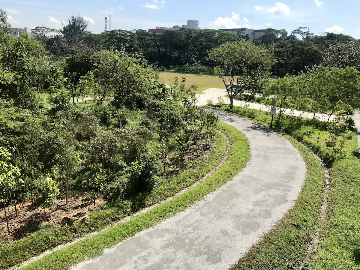
After Hillview MRT, you have reached the central section of the Railroad Corridor, and arguably the best (and most complete) section. At least, the most family-friendly section. At a cool 4km in length, with a couple of historic truss bridges you can walk across, an abundance of wildlife, and most importantly, shade, this is a perfect day outing with the kids.
As such, I plan to bring my boys (ages 8 and 6) to undertake this section later this summer.
Bukit Timah Nature Reserve
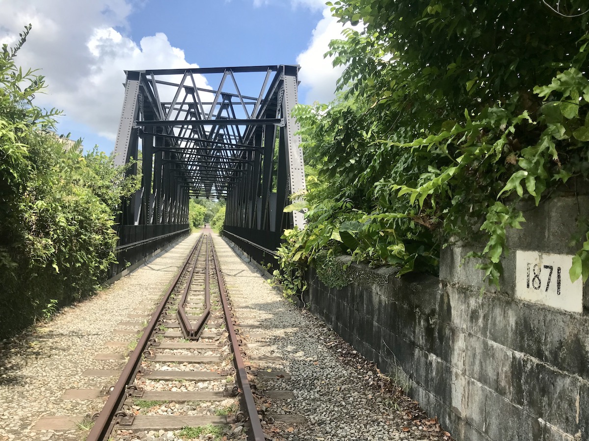
The north end of the central section begins at the Upper Bukit Timah Truss Bridge. According to the information sign at this lovely spot, the truss bridge was built in 1932 to allow “trains to move unimpeded above Dunearn-Bukit Timah Road and Upper Bukit Timah Road.”
A total of two truss bridges remain in place in the central section and, reopened in 2021 after two years of extensive refurbishment, you get to walk across them as part of your journey on the Rail Corridor. You can also learn the difference between a Baltimore truss bridge and a Pratt truss bridge, but I won’t spoil the surprise here.

Near the Upper Bukit Timah Truss Bridge, and Hillview MRT Station, is the Rail Mall. The row of shops and restaurants are located in historic railroad buildings gussied up with ironwork decorations. Most notably, I saw a Starbucks located here.
Between the two truss bridges, you also get to pass through the Bukit Timah Nature Reserve. Enterprising adventurers can leave the Rail Corridor here and explore the expansive nature reserve. The reserve is home to Singapore’s highest point (Bukit Timah Hill coming in at a whopping 163m in height) and some of the island’s only virgin rainforest.
It was one of several nature reserves established in the early days of Singapore, but the rest were, surprise, surprise, turned over for logging, because, you know, commerce. Only the Bukit Timah Forest Reserve was preserved.
The Rail Corridor skirts the edge of reserve and for two kilometers or so you can pay witness to some of that pristine nature, especially the wildlife, with colorful butterflies flitting about and, of course, the monkeys.
Now, back to that 2001 summer day in the Valle Vidal. As I was nearing civilization (a dirt road used by cattle ranchers), I came upon a black bear foraging in the tall grasses and wildflowers. It ignored me as I passed it by with just a few meters of distance between us.
It was titillating.
The black bear is a cousin to the racoon, and as such is a scavenger happy to forage for produce and animal carcasses. For the most part they leave humans alone. Part of the thrill of hiking is to see wild beasts in their natural habitat. And unfortunately I have a habit of trying to sneak in too close for a picture.
Earlier that summer I had spotted a bear about 20 meters off the trail and I crept in the underbrush to snap a photo. When the photo came back from the photomat (remember those?), I saw that the bear was glaring at me as it guarded over a bloody deer carcass.

In the Boundary Waters of Minnesota I purposely chose a route where there was a recent black bear sighting. We sighted the mama black bear all right, and her cub, as they circled our camp while we cooked up a pot of beef stew.
When my wife and I went backpacking in Yellowstone our first campsite was above a lake where grizzly bear were seen from time to time taking sips of water.
We didn’t see any grizzly bears in Yellowstone, but I did meet a long-tailed macaque in Bukit Timah Nature Reserve.
It was blissfully sitting at the side of the trail. I thought to myself, “I plan to write a blog post about this hike and a picture of a monkey would certainly enliven the photo selection.”

So as I came upon the monkey, I was but a few feet away when I hunkered down with iPhone in hand. That’s when the monkey let out a blood-curdling shriek and charged at me.
I gobbled like a plucked goose. I backpedaled, fully expecting the macaque to shred my knees with its teeth and claws.
Thankfully earlier on the trip I had stopped to read a warning sign. (Which specifically said do not approach the monkeys, and for the love of god don’t make them feel cornered.) It also said that if a monkey does charge at you, calm down and back away slowly.
Within that split second I had the wherewithal to remember that advice. I stopped my retreat. I threw my hands in the air in what I hoped was a sign of peace. I took slow steps away, and profusely apologized. “Sorry, sorry,” I said. “Please just let me go.”
The monkey seemed to accept this apology. It abruptly stopped its charge. It walked away cooly and gave me one side glance as if to say, “That’s right, bitch.”

There are lots of monkeys in Singapore’s nature reserves. Many of them are accustomed to humans and will peacefully allow you to take their picture. Make sure you do it from a safe distance and don’t make any strange movements or accidentally corner them. Or you will feel the wrath.
The only positive thing from the experience was that at least no one was around to see my bombastic display of idiocy.
After exiting the Bukit Timah Nature Reserve, you cross the Bukit Timah Truss Bridge over the buzzing Pan-Island Expressway. On the other side you reach the Bukit Timah Railway Station community node.
This is a lovely spot to refresh and experience a bit of Singapore’s unique history. The Bukit Timah Railway Station itself, opened in 1932, has been restored to its original state and repurposed as a heritage gallery. There is a café on site offering gelato, all-day breakfast, as well as beer.

There is also the restored Railway Staff Quarters, a spice garden, covered picnic shelters, and a small outdoor auditorium of sorts. A great stop especially if you are with kids.
The railway station signifies the end of the central section of the Railroad Corridor, and thus begins the southern section.
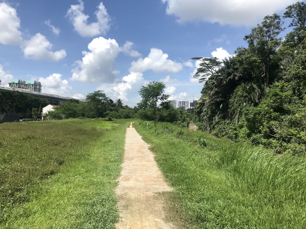
The 10km southern section can be split into two separations – Clementi Forest, and not Clementi Forest.

Clementi Forest
This was my first foray into Clementi Forest, and it is well worth it. The largest unprotected forest in Singapore’s Green Corridor is home to nearly 100 species of jungle plants, including some rare specimens.
This was the first time along the Railroad Corridor where I felt truly immersed in nature. No traffic was to be heard. There was little sign of civilization (until an airplane flew overhead).
The trail passes by two rivers and several smaller streams, leaving the path a bit muckier and more natural. I saw quite a few monitor lizards lazing about in the sun alongside the trail, and in the middle of the trail.
The chirping of birds and drone of insects was in constant harmony, and the swaths of natural jungle extended beyond vision (rather than merely providing a shield from the expressway on the other side).

Here you will also find the Bukit Timah Diversion Canal. There is a manmade waterfall here, and at the time of my visit the large park area was gated off from visitors as it was undertaking a fairly massive reconstruction project. It will be exciting to see what is made of this green space.
Upon leaving Clementi Forest, the Rail Corridor then weaves its way through the upscale residential area of Holland Village. The number of trail runners increased here as there is more natural shade, and access points lead off into personal properties. This is a good section of the trail if you want to see the back doors of the rich.
I ended my hike at Buona Vista MRT Station. There were directional signs along the Railroad Corridor clearly marking the way to the station. (The Rail Corridor is well-marked throughout – it’s just when you get off the trail where signage is lacking.)

There was still a good seven kilometers of the southern section that I didn’t touch. According to other bloggers, the southernmost link of the Rail Corridor is the most humdrum.
Overall, the entire route of the Rail Corridor is steadily flat. While I hiked a total of 17 kilometers, I was able to go at a rather brisk pace and finish in three-and-a-half hours, which included a stop for lunch and a heart-attack inducing monkey encounter.
If you are training for a hike outside of Singapore, the Railroad Corridor is as good as any place for practice. At about the same distance as a half-marathon, it’s also a good place for long-distance runners to go for a PR time. Mostly, I would recommend it for cyclists who want to get in a good morning ride.
If you find yourself staying in Singapore for an extended length of time, and need a good dose of green therapy, the Rail Corridor will nicely provide the relief.


2 responses to “Hiking the Rail Corridor in Singapore”
[…] The abundant wildlife, the pristine nature preserves, the wide-open starry skies, the honest appraisal of Western Australia’s reprehensible mistreatment of the native Noongar people, it was a refreshing break from the big city of Singapore, where the sound of traffic and construction follows you on the nature trails. […]
[…] already written an entire blog about the Rail Corridor, the trail that nearly runs the entire length of Singapore from north to […]